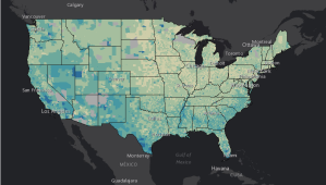
The Census Bureau’s ROAM tool. (Screenshot) Here are the GIS tools that will support the 2020 census The Census Bureau plans to use GIS-enabled tools to find where citizens live, encourage them to respond to the census and record their responses. Jan 31, 2019 By Tajha Chappellet-Lanier
D.C. by satellite (BeyondDC / Flickr) As Hurricane Florence hits, USDA is leveraging GIS for better emergency communications The mapping tool could lead to quicker and more intuitive building of media distribution lists. Sep 13, 2018 By Tajha Chappellet-Lanier
(Getty Images) NGA signs new multi-year contract with Esri’s ArcGIS The market-leading GIS company's technology has been part of the National Geospatial-Intelligence Agency's mission for several decades. Jul 25, 2018 By Tajha Chappellet-Lanier
A portion of the Library of Congress’ “Story Map” about newspapers published in Japanese-American internment camps during World War II. The Library of Congress is experimenting with GIS The "Story Maps" applications are intended to "tell the incredible stories of the Library’s collections through narrative, multimedia, and interactive maps." Apr 30, 2018 By Tajha Chappellet-Lanier
DHS releases 250 geospatial data sets on U.S. infrastructure The Department of Homeland Security is opening 250 sets of geospatial data about the location of vital industries across the country to the public. Feb 25, 2016